Project Nominated for RIBA Dissertation Medal 2026
*
Project Nominated for RIBA Dissertation Medal 2026 *
Submitted in April 2026 in fulfillment of Artefact (Dissertation) requirements in Stage 5 for a degree in Masters of Architecture at the University of Kent at Canterbury, School of Arts and Architecture.
Layered Fortification:
Mapping the Extant Fabric at St. Gregory’s Curtain Wall of Lower Fort St. Elmo, Malta, from 1551 to 2026 via a Chronological Stratigraphic Physical Model.
Abstract
This study produces a 1:200 scale stratigraphic model of St. Gregory’s Curtain Wall at Lower Fort St. Elmo, Malta. By synthesizing archival data and photogrammetry, the artefact documents the fort’s chronological evolution. It bridges gaps in heritage documentation, providing a tactile exploration of historical layers within the wall for public heritage education prior to potential redevelopment.
Introduction
Malta is a small archipelago Republic situated between Sicily and north Africa; its position at the junction of the eastern and western Mediterranean basins has given it a particularly high “strategic relevance in the history of the region” (Spiteri, 2017). The islands have been intermittently inhabited since the Mesolithic period starting in 6500 BC (Scerri et. al., 2025), with the earliest structures, the Megalithic Temples at Tarxien and Ħaġar Qim, surviving from approx. 3600 BC (Sazonov, 2025).
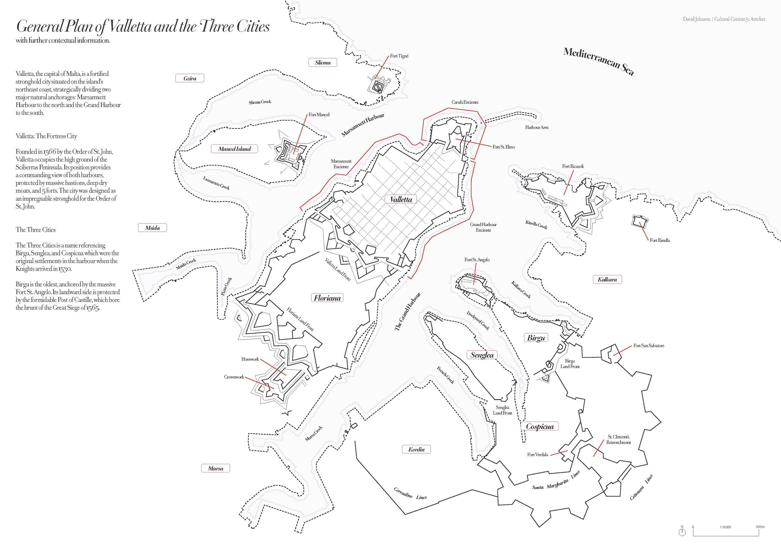
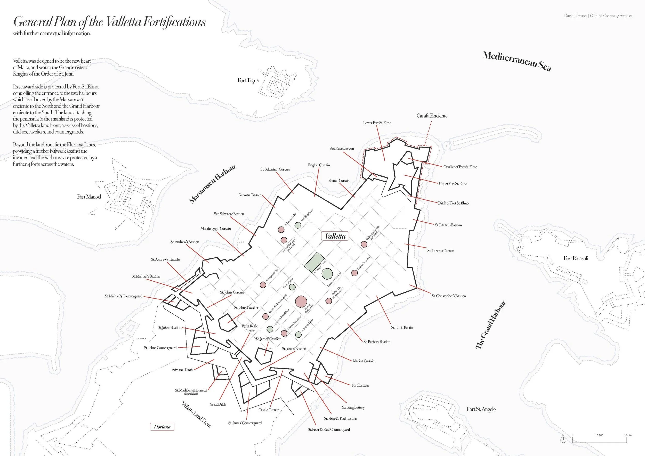
Many civilisations have since lay claim to the islands of Malta, Gozo, and Comino, those most pertinent to this study include: the Hospitaller Order of Saint John of Jerusalem, of Rhodes, and of Malta in 1530; the French Empire in 1798; the British Empire in 1800; and the current Government of the Republic of Malta from 1964 (Spiteri, 2017). Millennia of conflicting civilisations have left behind a breadth of military history, fortifications, and strongholds for archaeologists, engineers, and architects to study. Among the surviving “60km of ramparts” (Spiteri, 2017) arguably the most impressive being the bastioned stronghold, Capital City of Valletta (Fig 1) built by the Order of St. John on the Sciberras Peninsula in 1566 (Hoppen, 1979).
In recent decades Malta has experienced an uplift in the tourism sector (Government of Malta, 2025), prompting the state-driven conservation of heritage assets to strengthen the national image and ‘rehabilitate’ “focal assets of Malta’s cultural-tourism product” (Restoration Directorate, 2015). Significant works were undertaken between 2007 and 2013 in the restoration of the fortifications at Valletta, Mdina, Birgu (Vittoriosa), the Gozo Citadel, and Senglea as part of the European Regional Development Fund (ERDF) Project 039; the €43.3 million allocated “represented the first ever major investment in modern times that has focused on the holistic conservation and preservation of Malta’s extensive network of historical fortifications” (Restoration Directorate, 2015). As part of the project, the ERDF also funded the creation of the ‘Fortifications Interpretation Centre’ – a kind of museum dedicated to a permanent exhibition of text, images, and models showcasing the island’s fortifications (Restoration Directorate, 2015; Heritage Malta, 2026).
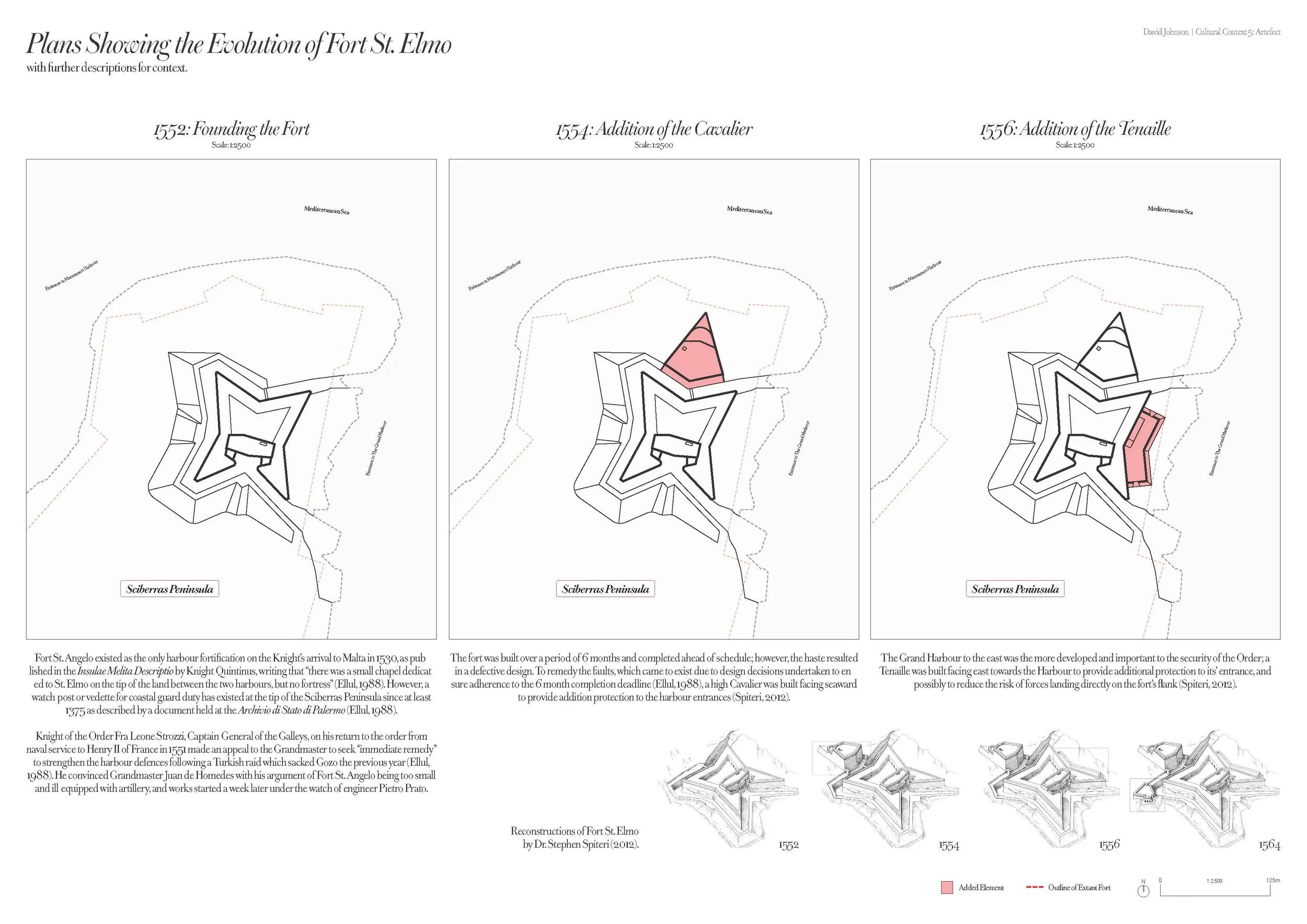
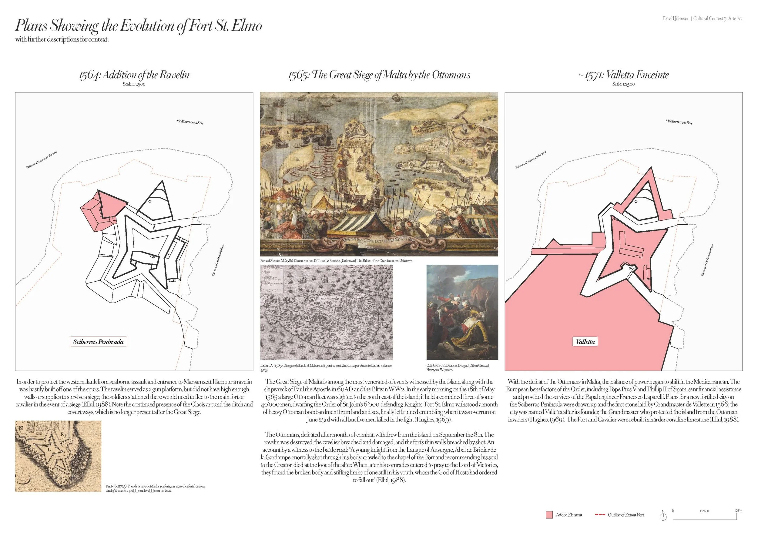
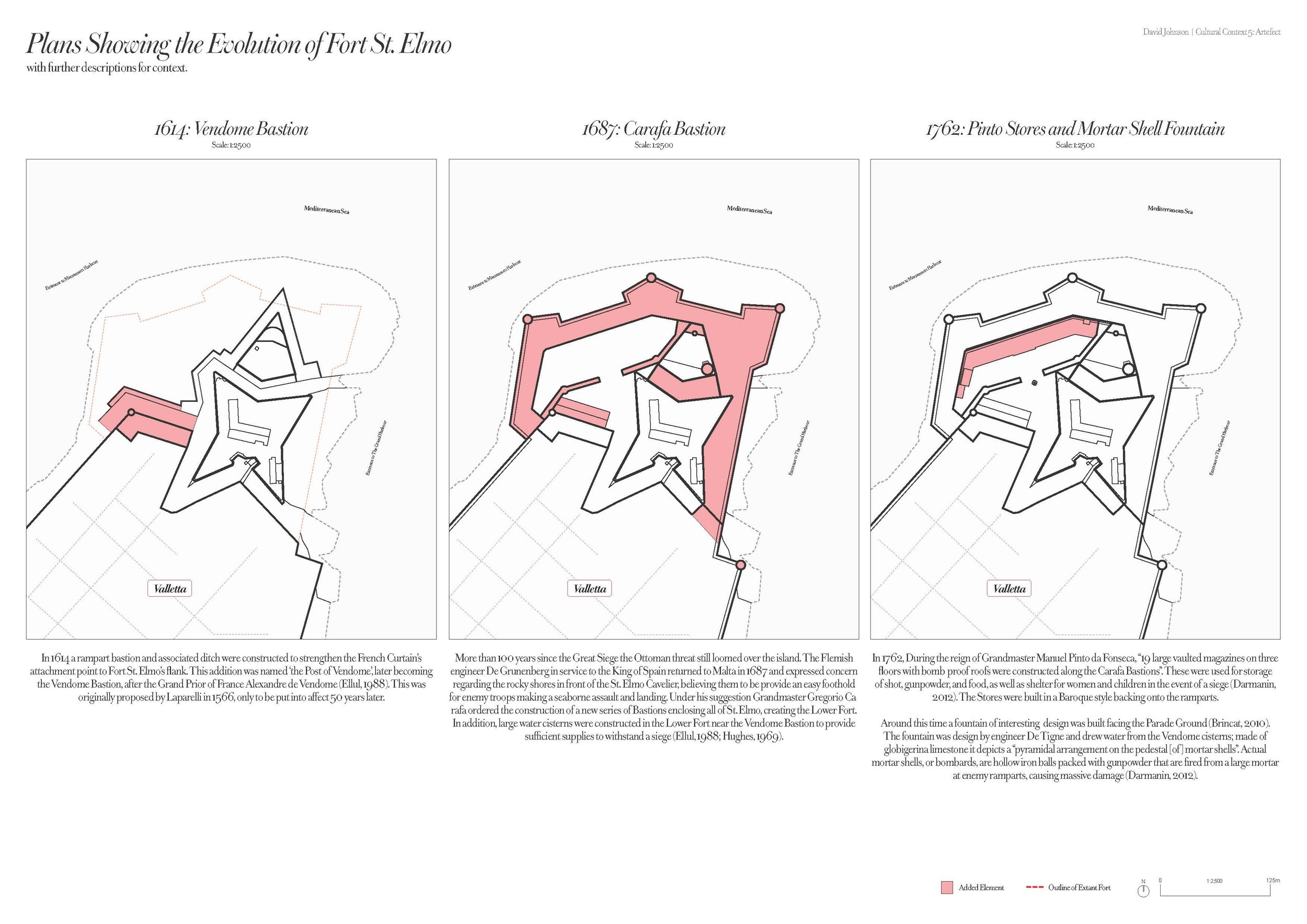
The focus of this investigation is Fort St. Elmo (Fig 2), a bastioned fortification at the tip of Valletta, built in 1552 to protect the entrance to the Marsamxett and Grand Harbours (Hoppen, 1979). The Fort is split into two parts, the Upper was reopened to the public in 2015 as the ‘National War Museum’ after extensive restoration works funded by the European Union in the 2007 funding cycle (Grand Harbour Regeneration Corporation, 2015); however, the Lower has remained mostly abandoned after the withdrawal of the British military in 1979 (Stephenson, 2004), with the neglect attributed to the complexity and high cost of the required conservation works. The most recent proposal for the conversion of the Lower Fort into a wellness retreat hotel has stalled due to scrutiny by UNESCO, who requested a heritage assessment, due to the proposal’s insensitivity to the Fort’s heritage (Vella, 2024).
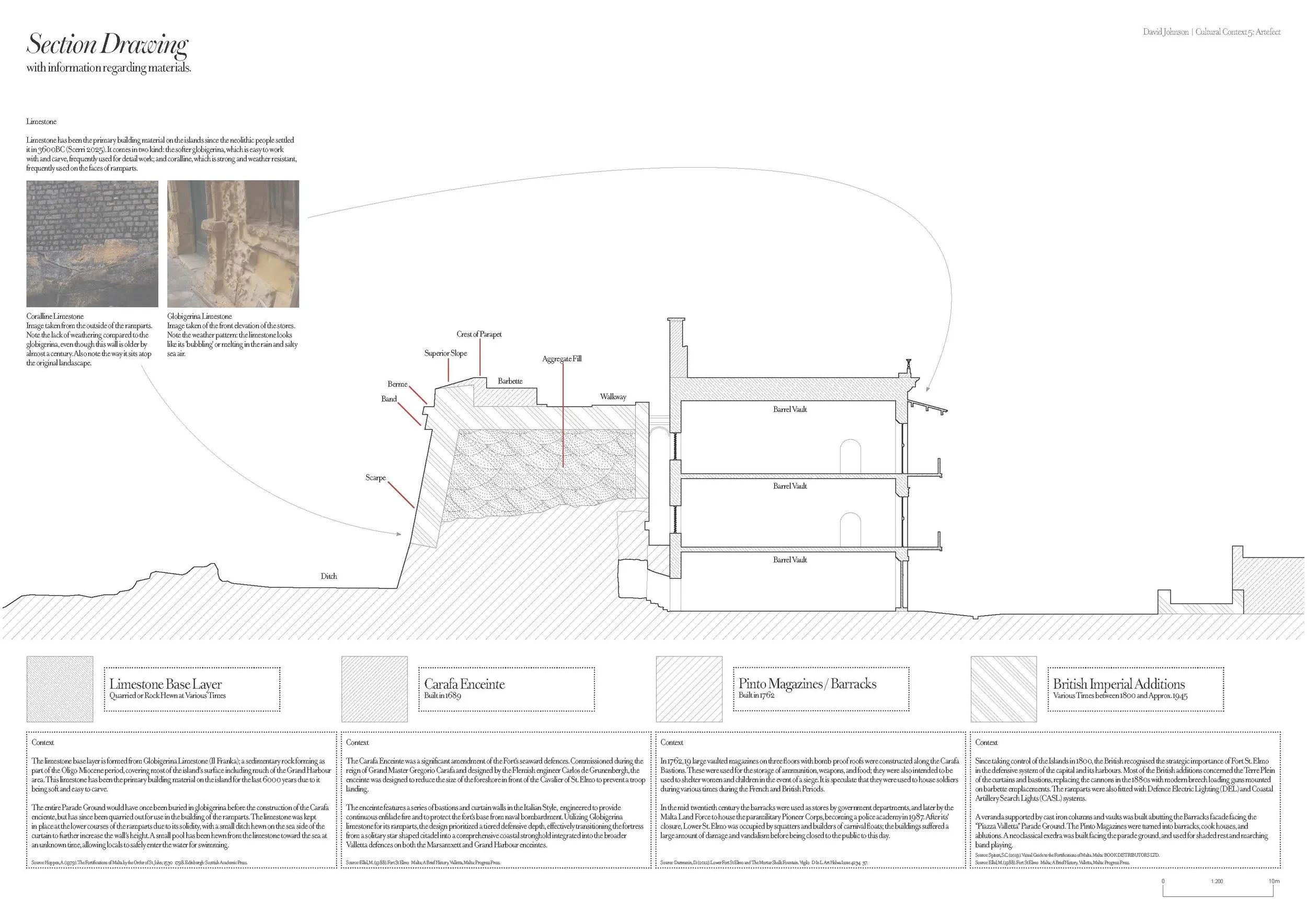
This artefact seeks to contribute to public heritage education and wider academic discourse concerning Malta’s fortification heritage by synthesising available data of the under-explored existing fabric at St. Gregory’s Curtain Wall of Lower Fort St. Elmo to develop a stratigraphic, chronological cross-sectional model. The artefact will explore the layering of historic fabric and document the existing strata conditions at a crucial point before the redevelopment of the Lower Fort. The goal behind the model is to unite the past and the present, and show the viewer information that is locked away behind the surface in a way no-one has yet done.
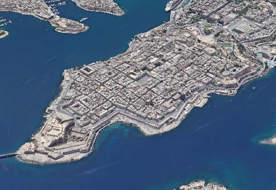
Figure 1 - Aerial View of the City of Valletta from Google Earth. 2026
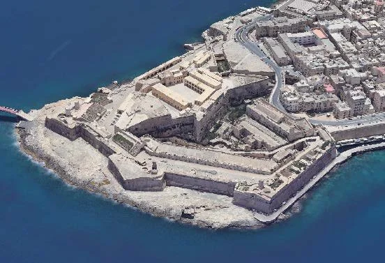
Figure 2 - Aerial View of Fort St. Elmo from Google Earth. 2026
Literature Review
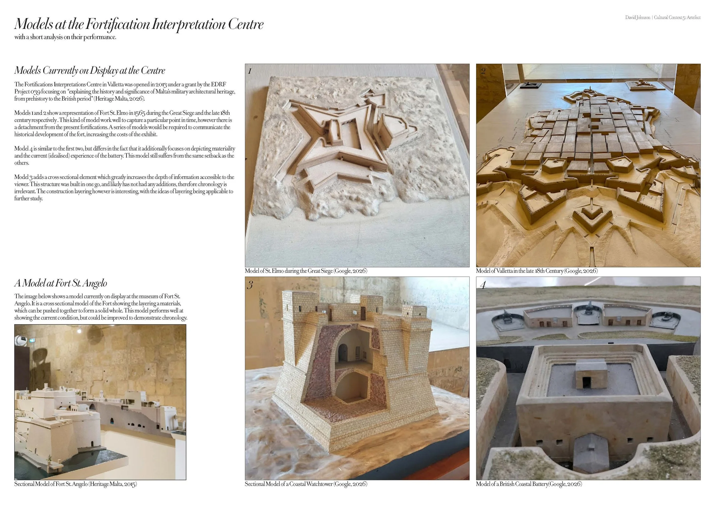
A review of information available online showed a wide variety of models on display at the Interpretations Centre, as well as at museum installations of other Heritage Malta locations. Notable examples include a model of Fort St. Elmo in 1565 before the Great Siege (Fig 3), and a model of Valletta in the 18th century (Fig 4). These models provide a valuable glimpse into specific points in the Fort’s history, however, fall short in relating those points to adjacent points in history and illustrating their conditions with a level of ‘realism’. Several models introduce a sectional element, in both cases relating to materiality and construction rather than chronology. The model of a Coastal Watchtower (Fig 5) provides construction detail down to the individual limestone blocks, while the model of Fort St. Angelo (Fig 6) provides a stratigraphic view separating the base rock, the aggregate infill, and the built elements. These models provide an additional axis of information but lack the ability to convey the building’s chronology (although it must be noted that that was not their objective).
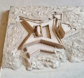
Figure 3 - Model of Fort St. Elmo before the Great Siege from the FIC. 2015
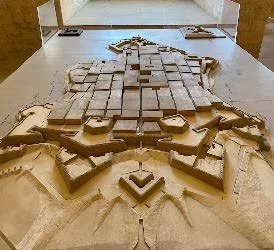
Figure 4 - Model of Valletta in the 18th Century from the FIC. 2015
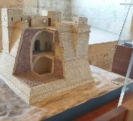
Figure 5 - Model of a Coastal Watchtower from the FIC. 2015
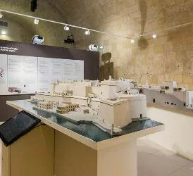
Figure 6 - Sectional Model of Fort St. Angelo by Heritage Malta. 2015
In the broader academic discourse, there has been much material recently published investigating the history and construction of the Maltese fortifications, frequently with an archaeological approach. Architect Quentin Hughes, stationed in Malta during WW2, became one of the first scholars to study the history of the fortifications through an academic lens, establishing the School of Architecture at the University of Malta in 1968 and publishing a seminal work titled “Fortress: Architecture and Military History in Malta”. Conversely, Architects and engineers such Carlos De Grunenberg (17th century) and the Royal Engineers (19th and 20th centuries) focused on the provision of military utility rather than heritage documentation; as a result, much of the available material is text-based, drawing from historical accounts and records of the Order as many drawings have been lost to time (Hoppen, 1979). However, there are artworks (Fig 7) and atlas maps (Fig 8) surviving which provide an invaluable overview of historic conditions, while lacking the accuracy needed to be relied upon for more granular detail.
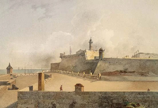
Figure 7 - “A Fort on Malta” by Forray Iv. 1857.
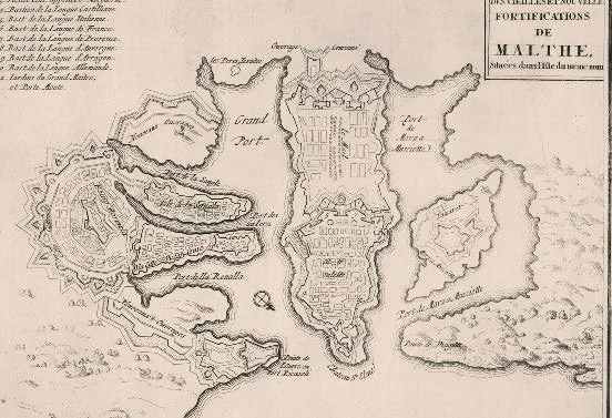
Figure 8 - “Plan des Vieilles et Nouvelle Fortifications de Malthe, Situees dan l’Isle du meme nom” by Nicolas de Fer. 1696.
With the lack of historic drawings to provide visual guidance, scholarly reconstructions focus on reverse engineering historically described conditions from extant buildings, artworks, and maps. Sketches by illustrator Steve Noon (Fig 9), and the work of Dr. Stephen Spiteri, have been instrumental in the advancement and dissemination of knowledge. Recently, ERDF Project 039 which Spiteri was a part of, conducted detailed investigations using LIDAR scanning (Fig 10), traditional surveying (Fig 11), and excavation works (Fig 12) of several high-profile ramparts around the islands in preparation for their rehabilitation (Conservation Directorate, 2015). However, these investigations did not extend to Fort St. Elmo. The most recent documentation of a granular scale available for Fort St. Elmo is from the Maltese National Archives by the British Royal Engineer Corps in the early 20th century, who documented the contemporary existing and modified conditions of the fort during their adaptation of the ramparts for modern defence (Fig 13 - Example, See Appendix for more).
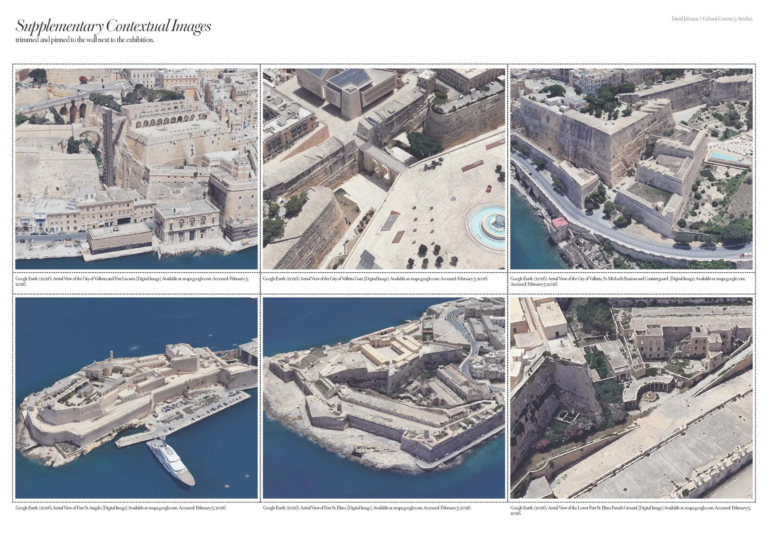
Supplementary data sources such as the Google Earth photogrammetry model extracted via ‘Earth2MsfsWPF’ (Fig 14), and urban exploration footage from Conrad Niel Gatt (Fig 15) and Therese Debono (Fig 16) are of a lower accuracy but may bridge gaps present in other knowledge.
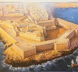
Figure 9 - Illustration of Fort St. Elmo in the mid-17th century by Steve Noon. 2004
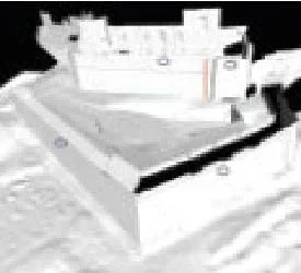
Figure 10 - LIDAR scan of Mdina by the Restoration Directorate. 2015
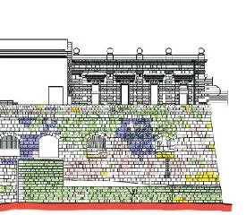
Figure 11 - Survey Drawing of Mdina by the Restoration Directorate. 2015
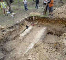
Figure 12 - Excavation Works at Mdina by the Restoration Directorate. 2015
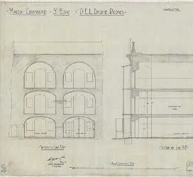
Figure 13 - DEL Engine Rooms by the Royal Engineers. 1934.
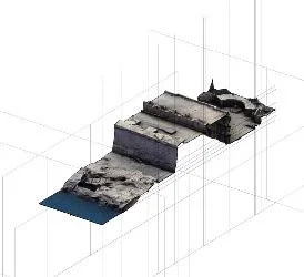
Figure 14 - Photogrammetry Model extracted from Google Earth. 2026.
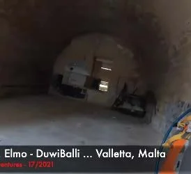
Figure 15 - Still from footage by Conrad Niel Gatt in Fort St. Elmo. 2021.
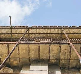
Figure 16 - Image of Pinto Barracks by Therese Debono. Unknown.
Methodology for Model Making
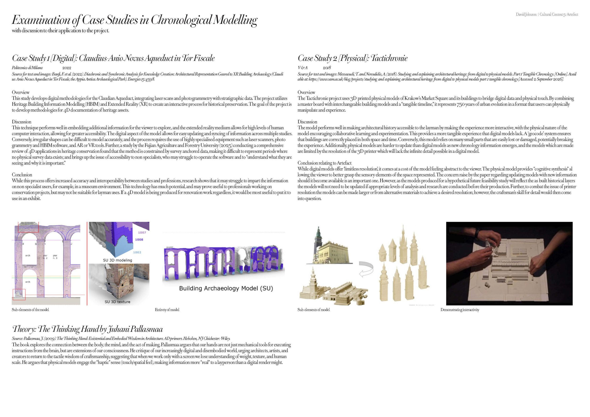
Inspiration was taken from two case studies in chronological modelling: (1) a 2022 study by Banfi, F. et al. which developed digital methodologies for the 4D modelling of the Claudian Aqueduct in Italy, resulting in a unique output stratified building layers (Fig 17); and (2), a study 2018 study by Messaoudi, T. and Neroulidis, A. which explored the concept of “Tactichronie” through a series of 3D-printed physical models of Krakow’s Market Square and its buildings to bridge digital data and physical touch (Fig 18). Elements of these case studies formed the basis of the artefact, combining the stratification approach from the first, with the physical removable modelling to provide an increased tactility and, per Pallasmaa (2009), engaging the “haptic” sense of touch and spatial feel to make the information more “real” than a digital image.
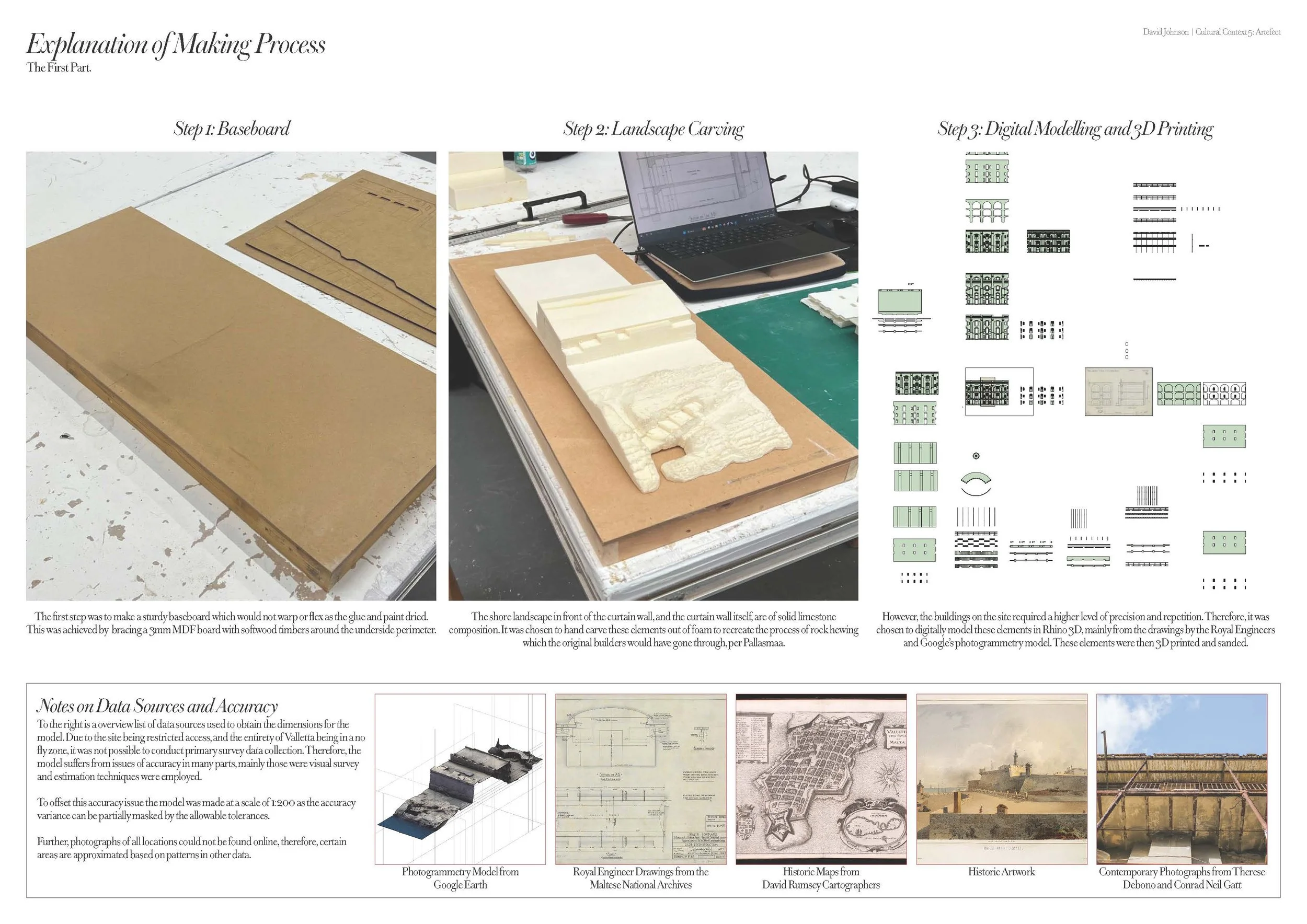
As no work could be found which accurately reconstructs a complete cross-section of St. Gregory’s Curtain Wall, and no physical models exist showing the existing conditions of the Lower Fort, the reconstruction culminating in this novel artefact was therefore required to synthesise a range of available data sources together to form a rigorous analysis of the existing conditions. All measurements were taken from orthographic drawings of the Royal Engineers where possible, then falling back to Google Earth’s lower accuracy photogrammetry model to bridge the gaps, then falling back to even lower accuracy visual surveying techniques and estimation where required. It was not possible to collect first hand survey or photogrammetry data as the site and its airspace are restricted by the authorities. For further information regarding the model making process steps, please see the included exhibition files.
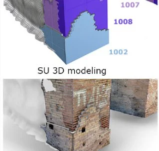
Figure 17 - Aquaduct Strata by Hu et. al. 2025.
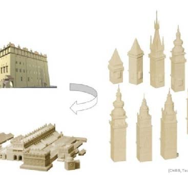
Figure 18 - Tactichronie Model by Messaoudi, T. and Neroulidis, A. 2018.
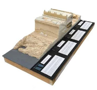
Figure 19 - The Final Model by David Johnson. 2026.
Discussion
The produced novel 1:200 scale physical model (Fig 19) to document the existing conditions on and below the surface at St. Gregory’s Curtain Wall of Lower Fort St. Elmo was able to communicate with acceptable clarity the separation and location of the fabric strata, showing the additive evolution of the fort over time. The model could make a valuable addition to the Fortification Interpretation Centre’s exhibition to aid in the ongoing efforts by Heritage Malta to educate visitors regarding the history and evolution of the fortifications. However, it was observed that the exhibition component provides valuable context to the model, showing that the exhibition can exist without the model, but the model can’t exist without the exhibition and provide the same level of clarity. Several other limitations have also been observed.
Firstly, there was the issue of accuracy due to the lack of possibility to collect primary data. Hand drawn archival traces and satellite photogrammetry models can provide acceptable accuracy at this scale, but more robust tools, or even a measuring tape, exist which can produce results with higher precision. The model could be amended in the future if access to survey is granted following a study of low-data locations within the model. However, the disassembly and reassembly would pose further challenges, so the prudent course would be to LIDAR or laser scan the curtain wall and buildings and constructed a refined second iteration model.
Secondly, the tactile and removable features of the model did not work as well as intended, providing limited options for exploration by the viewer. The removable Pinto Stores building merely facilitated the viewing of tight spaces. The second iteration model could lean more heavily on the “Tactichronie” case study to provide replaceable elements within the model to allow the viewer to added and subtract to discover the historical sequence of the wall’s construction. This also brings into focus the fact that the exhibition can show more than the current model, having the ability to show elements lost to time which cannot possibly appear on the current model, for example the ravelin of which no trace remains. A swappable kit of parts can, however, provide the ravelin – allowing the fort to be visible in all configurations dating back to its initial construction in 1551.
Thirdly, the model and its explanation of the chronology was very reliant on text, and therefore inaccessible to the blind, the neurodivergent, or children. A further study could examine how the stratigraphy can be communicated through more tactile means, perhaps relating to the second point raised above. The model elements can be made of sturdier materials, such as 3D prints or timber, allowing for rougher handling.
Conclusion
The novel stratigraphic model successfully illustrates the additive evolution of St. Gregory’s Curtain Wall, bridging the gap between historical records and physical representation in an understudied segment of Malta’s ramparts. While archival synthesis provided a functional baseline, the study identified limitations in data precision and tactile modularity. Future iterations should incorporate primary LIDAR scans and more robust, swappable components to represent lost structures like the ravelin. By engaging the haptic senses, this project provides a vital record of Lower Fort St. Elmo’s existing fabric. It offers a novel tool for academic discourse, providing information to aid sensitive conservation as the site faces imminent redevelopment.
Pin-Up Crit
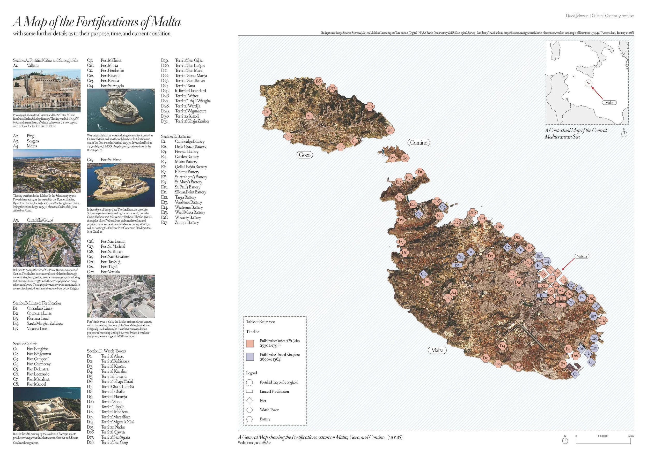
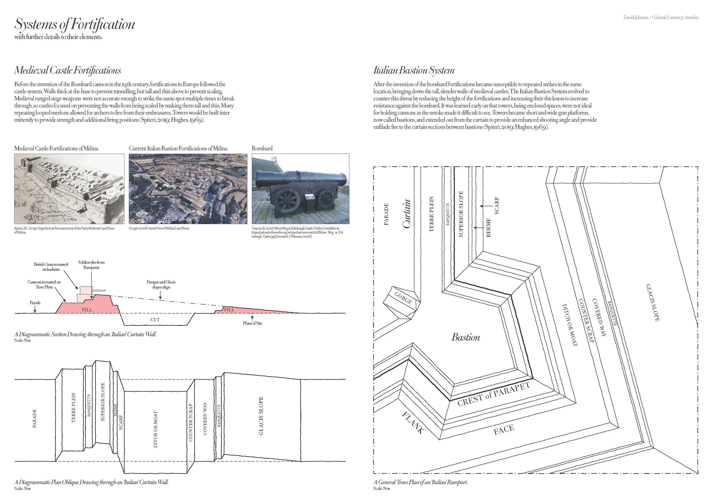
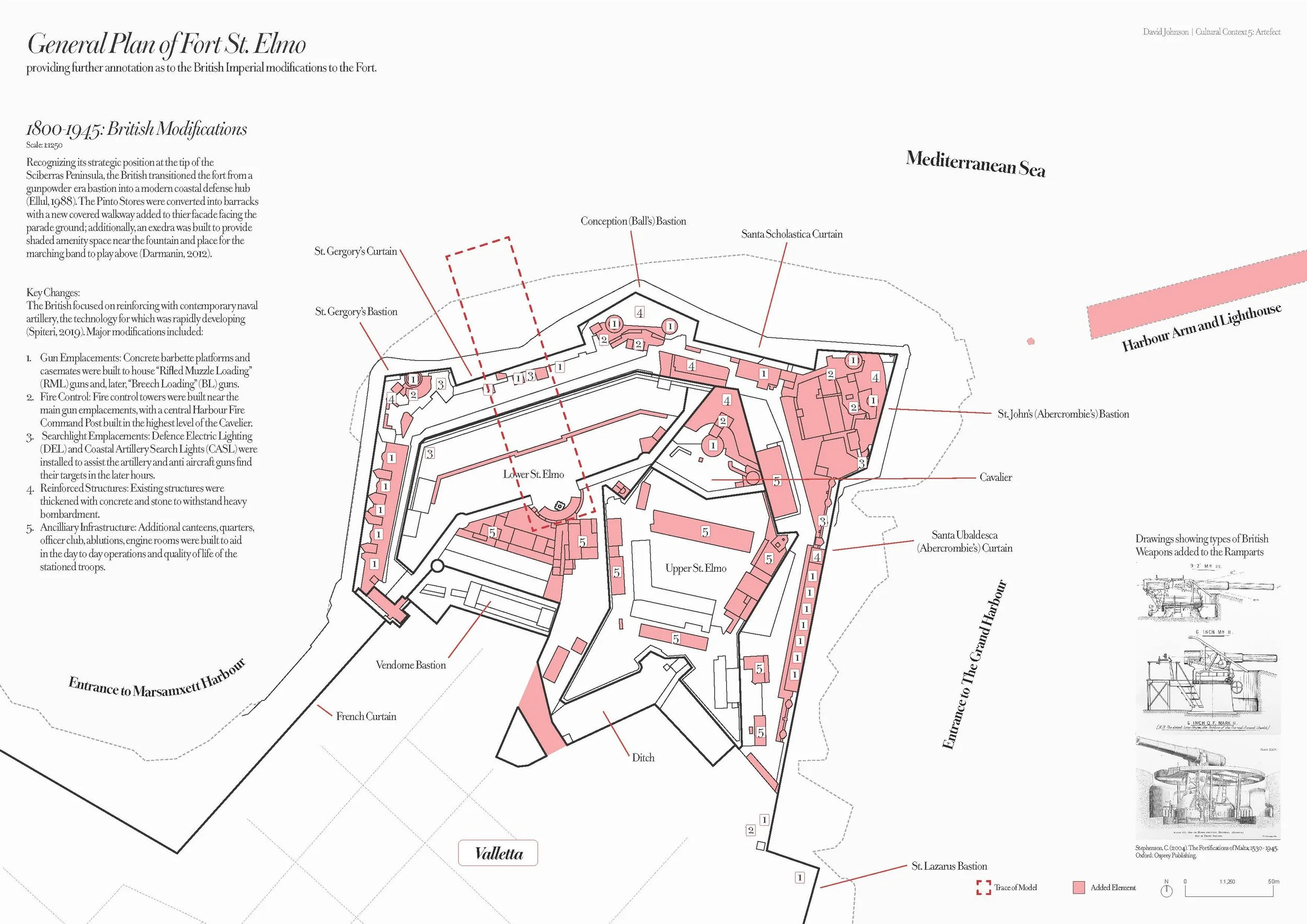
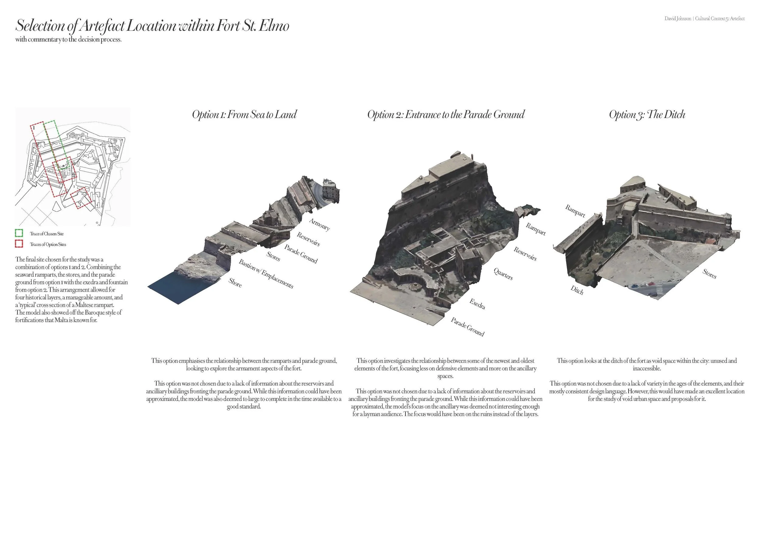
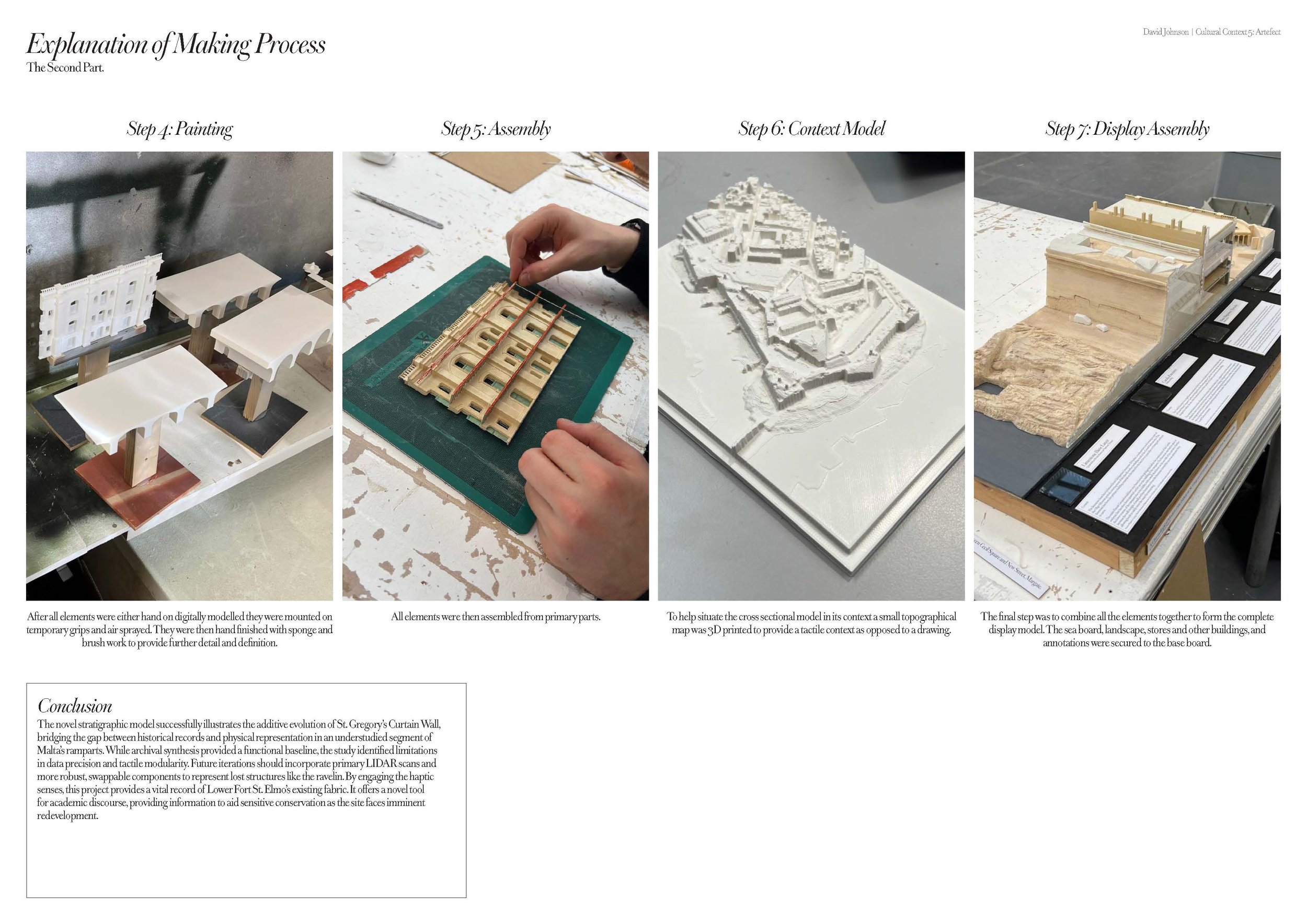
Please see below the additional research pages created for, and presented at, the final crit for the Artefact module.
Bibliography
Banfi, F. et al. (2022). Diachronic and Synchronic Analysis for Knowledge Creation: Architectural Representation Geared to XR Building Archaeology (Claudius-Anio Novus Aqueduct in Tor Fiscale, the Appia Antica Archaeological Park). Energies 15:4598.
Brincat, F. (2010). Bali de Tigne : Knight of Malta, Commisioner of Fortifications and Military Engineer (1716-1801). Master of Architecture, University of Malta. Available at: https://www.um.edu.mt/library/oar/handle/123456789/73374 [Accessed: 7 February 2026].
Carroll, F.A. et al. (2012). Holocene climate change, vegetation history and human impact in the Central Mediterranean: evidence from the Maltese Islands. Quaternary Science Reviews 52:24–40.
Darmanin, D. (2012). Lower Fort St Elmo and The Mortar Shells Fountain. Vigilo - D In L-Art Helwa Issue 41:34–37. Ellul, M. (1988). Fort St Elmo - Malta; A Brief History. Valletta, Malta: Progress Press.
Government of Malta (2025). Public Service. MTA Drives Tourism Growth with Major Summer Events and Quality Focus [Online]. Available at: https://publicservice.gov.mt/en/news/mta-drives-tourism-growth-with-major-summer-events-and-quality-focus [Accessed: 4 February 2026].
Grand Harbour Regeneration Corporation (2015). Fort St. Elmo. [Online]. Available at: https://ghrc.gov.mt/portfolio/fort-st-elmo/ [Accessed: 2 September 2026].
Heritage Malta (2026). Fortress Builders Interpretation Centre. [Online]. Available at: https://heritagemalta.mt/explore/fortressbuilders-interpretation-centre/ [Accessed: 4 February 2026].
Hoppen, A. (1979). The Fortifications of Malta by the Order of St. John; 1530 - 1798. Edinburgh: Scottish Academic Press.
Hu, Y., Gao, B. and Chen, H. (2025). Application of 4D Technologies in Heritage: A Comprehensive Review. Buildings 15:4369.
Hughes, Q. (1969). Fortress: Architecture and Military History in Malta. London: Lund Humphries.
Messaoudi, T. and Neroulidis, A. (2018). Studying and explaining architectural heritage: from digital to physical models. Part 1 Tangible Chronology. [Online]. Available at: https://www.vam.ac.uk/blog/projects/studying-and-explaining-architecturalheritage-from-digital-to-physical-models-part-1-tangible-chronology [Accessed: 2 September 2026].
Pallasmaa, J. (2009). The Thinking Hand: Existential and Embodied Wisdom in Architecture. AD primers. Hoboken, NJ Chichester: Wiley.
Restoration Directorate (2015). The Restoration and Rehabilitation of the Historic Fortifications of Malta and Gozo ERDF 039. [Online]. Tarxien, Malta: Gutenberg Press. Available at: https://restawr.gov.mt/wp-content/uploads/2024/04/ERDF BOOK-2015.pdf [Accessed: 7 February 2026].
Sazonov, V. (2025). Chapter 6; The Prehistoric Sacred Places/Temples of Malta and Western Asia (IX–Mid IV Millennia BC). In: Ulanowski, K. and Warburton, D. A. eds The Human and the Divine: Aspects of Sanctity in Time and Space. BRILL, pp. 189–208. Available at: https://brill.com/view/title/65074 [Accessed: 4 February 2026].
Scerri, E.M.L. et al. (2025). Hunter-gatherer sea voyages extended to remotest Mediterranean islands. Nature 641:137–143. Sire, H.J.A. (1994).
The Knights of Malta. New Haven and London: Yale University Press. Spiteri, S.C. (2012). Fort St Elmo 1565. [YouTube]. 4:33. Available at: https://www.youtube.com/watch?v=Ia4rB1f7RhI [Accessed: 7 February 2026].
Spiteri, S.C. (2019). Visual Guide to the Fortifications of Malta. Malta: BOOK DISTRIBUTORS LTD.
Stephenson, C. (2004). The Fortifications of Malta; 1530 - 1945. Oxford: Osprey Publishing.
Vella, M. (2024). St Elmo ‘laguna hotel’ UNESCO stopped: €170,000 kickback alleged. Malta Today [Online]. Available at: https://www.maltatoday.com.mt/news/national/129395/st_elmo_laguna_hotel_unesco_stopped_170000_kickback_alleged [Accessed: 13 February 2026].
Figure References
Figure 1 - Google Earth. (2026). Aerial View of the City of Valletta. [Digital Image]. Available at: maps.google.com. Accessed: February 5, 2026.
Figure 2 - Google Earth. (2026). Aerial View of Fort St. Elmo. [Digital Image]. Available at: maps.google.com. Accessed: February 5, 2026.
Figure 3 - Heritage Malta. (2015). Model of Fort St. Elmo before the Great Siege. [Digital Image]. Available at: https:// heritagemalta.mt/explore/fortress-builders-interpretation-centre/. Accessed: February 24, 2026.
Figure 4 - Heritage Malta. (2015). Model of Valletta in the 18th Century. [Digital Image]. Available at: https://heritagemalta.mt/ explore/fortress-builders-interpretation-centre/. Accessed: February 24, 2026.
Figure 5 - Heritage Malta. (2015). Model of a Coastal Watchtower. [Digital Image]. Available at: https://heritagemalta.mt/ explore/fortress-builders-interpretation-centre/. Accessed: February 24, 2026.
Figure 6 - Heritage Malta. (2015). Sectional Model of Fort St. Angelo. [Digital Image]. Available at: https://heritagemalta.mt/ explore/fort-st-angelo/. Accessed: February 24, 2026.
Figure 7 - Iv, F. (1857). A Fort on Malta. [Plate]. Unknown.
Figure 8 - Fer, N. de (1696). Plan des Vieilles et Nouvelle Fortifications de Malthe, Situees dan l’Isle du meme nom. [Online]. Available at: https://www.davidrumsey.com/luna/servlet/detail/RUMSEY~8~1~298672~90069810:Plan-des-Vieilles-et Nouvelle-Forti?sort=pub_list_no_initialsort%2Cpub_date%2Cpub_list_no%2Cseries_no# [Accessed: 7 February 2026].
Figure 9 - Noon, S. (2004). Fort St. Elmo in the mid-17th century. [Illustration] In Stephenson, C. The Fortifications of Malta; 1530 - 1945. Oxford: Osprey Publishing.
Figure 10 - Restoration Directorate (2015). LIDAR scan of Mdina. In: The Restoration and Rehabilitation of the Historic Fortifications of Malta and Gozo ERDF 039. [Online]. Tarxien, Malta: Gutenberg Press. Available at: https://restawr.gov.mt/wp-content/ uploads/2024/04/ERDF-BOOK-2015.pdf [Accessed: 7 February 2026].
Figure 11 - Restoration Directorate (2015). Survey Drawing of Mdina. In: The Restoration and Rehabilitation of the Historic Fortifications of Malta and Gozo ERDF 039. [Online]. Tarxien, Malta: Gutenberg Press. Available at: https://restawr.gov.mt/wp content/uploads/2024/04/ERDF-BOOK-2015.pdf [Accessed: 7 February 2026].
Figure 12 - Restoration Directorate (2015). Excavation Works at Mdina. In: The Restoration and Rehabilitation of the Historic Fortifications of Malta and Gozo ERDF 039. [Online]. Tarxien, Malta: Gutenberg Press. Available at: https://restawr.gov.mt/wp content/uploads/2024/04/ERDF-BOOK-2015.pdf [Accessed: 7 February 2026].
Figure 13 - Royal Engineers. (1934). PDM61190 - Malta Command - St Elmo - D.E.L. Engine Rooms - Royal Engineers. [Technical Drawing]. Available from the Maltese National Archives at: https://arkivji.org.mt/. [Accessed: 20 January 2026].
Figure 14 - Google Earth. (2026). Fort St. Elmo. [Digital Photogrammetry Model]. Available at: maps.google.com. Accessed: February 5, 2026.
Figure 15 - Gatt, C.N. (2021). Fort St. Elmo - DuwiBalli ... Valletta, Malta - 16th Century Great Siege ...CNG Trekventures 17/2021. [YouTube Video]. 15:34. Available at: https://www.youtube.com/watch?v=Jin0ZKETozA [Accessed: 2 February 2026].
Figure 16 - Debono, T. (Unknown) Image of Pinto Barracks. [Photograph] Available at: https://www.theresedebono.com/lower-st elmo-valletta. [Accessed: 2 February 2026].
Figure 17 - Hu, Y., Gao, B. and Chen, H. (2025). Application of 4D Technologies in Heritage: A Comprehensive Review. Buildings 15:4369.
Figure 18 - Messaoudi, T. and Neroulidis, A. (2018). Studying and explaining architectural heritage: from digital to physical models. Part 1 Tangible Chronology. [Online]. Available at: https://www.vam.ac.uk/blog/projects/studying-and-explaining-architectural heritage-from-digital-to-physical-models-part-1-tangible-chronology [Accessed: 2 September 2026].
Figure 19 - David Johnson. (2026). 1:200 Stratigraphic, Chronological, Cross-sectional model of the Extant Fabric at St. Gregory’s Curtain Wall of Lower Fort St. Elmo, Malta. [Photograph]